Burnley (district)
Niet-metropolitaans district in Engeland  | |||
|---|---|---|---|
 | |||
  | |||
| Situering | |||
| Land | Engeland | ||
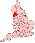
| County | Lancashire | ||
| Regio | North West England | ||
| Coördinaten | 53°47'NB, 2°15'WL | ||
| Algemeen | |||
| Oppervlakte | 110,6840[1] km² | ||
| Inwoners (2018[2]) | 88.527 (800 inw./km²) | ||
| ONS-code | E07000117 | ||
| Detailkaart | |||
 | |||
| |||

Burnley is een district in het shire-graafschap (non-metropolitan county OF county) Lancashire en telt 89.000 inwoners. De oppervlakte bedraagt 111 km². Hoofdplaats is Burnley.
Van de bevolking is 15,1% ouder dan 65 jaar. De werkloosheid bedraagt 3,1% van de beroepsbevolking (cijfers volkstelling 2001).
Civil parishes in district Burnley
- Briercliffe
- Cliviger
- Dunnockshaw
- Habergham Eaves
- Hapton
- Ightenhill
- Padiham
- Worsthorne-with-Hurstwood.
Bronnen, noten en/of referenties
- ↑ Office for National Statistics → Download → SAM_for_Administrative_Areas_(2018).zip → SAM_LAD_DEC_2018_UK.xlsx. Gearchiveerd op 7 april 2023.
- ↑ https://www.ons.gov.uk/file?uri=/peoplepopulationandcommunity/populationandmigration/populationestimates/datasets/populationestimatesforukenglandandwalesscotlandandnorthernireland/mid20182019laboundaries/ukmidyearestimates20182019ladcodes.xls Schatting Office for National Statistics: knop MYE5 → kolom Estimated Population mid-2018]
- Volkstelling 2001, Office for National Statistics


