Xochitlán Todos Santos
Municipality and town in Puebla, Mexico

Coat of arms

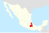
Location of the municipality in Puebla
(2010)
Xochitlán Todos Santos (municipality) is one of the 217 town and municipalities of the Mexican state of Puebla. It was founded in 1895.[1]
Name
Xochitlán, name composed of the Nahua words, "xochitl", flower, and "tlan", together. The full name means "among the flowers".[1]
Demography
According to the last census by INEGI in 2010, the municipality has a total population of 6,049 inhabitants, which gives it an approximate population density of 37 inhabitants per square kilometer.[2]
Economy
The primary industry is agriculture, since the inhabitants dedicate themselves mostly to the sowing of corn, beans, alfalfa and sorghum. In second place we find livestock, a greater number of ranchers are dedicated to raising cattle or cattle and pigs. Unlike a minority that is dedicated to raising sheep, goats, horses, poultry and beekeeping.
History
Xochitlán Todos Santos was founded by Olmec Xicalanca groups that settled there in pre-Hispanic times, dominated by Tepeaca, a tributary of Mexico. It belonged to the old district of Tecamachalco and in 1895 a free municipality was established. There is a parish dedicated to the Virgin of the Assumption dated from the 17th century. Located here is the Chapel of the Hacienda de San Jerónimo Álfaro founded by the Jesuits dedicated to Santa Rosalía. At the main entrance there is an underground tunnel to Tecamachalco, which was last used during the Mexican Revolution.[citation needed]
Geography
The municipality is located roughly 1.9 km (1.2 mi) above sea level and covers an area of 163.72 km2 (63.21 sq mi).[2] To the north, it borders the municipalities of Tochtepec and Tecamachalco, to the west is Huitziltepec and Molcaxac, to the south are the municipalities of Juan N. Mendez and Tepexi de Rodríguez, and to the east are Yehualtepec and the municipality of Tlacotepec de Benito Juárez.[1]
Xochitlán is connected by 3 highways: Xochitlán-Tecamachalco, Xochitlán-Tlacoptec de Benito Juárez and Xochitlán-Dolores Hidalgo. As for collective transportation, the municipality has Route 19 bound for Tlacotepec and Tecamachalco.
Climate
The climate is temperate sub-humid with rains in the summer; with average annual temperature between 12 and 18 °C (54 and 64 °F), precipitation of the driest month being less than 40 millimetres (1.6 in); percentage of winter precipitation with respect to the annual is less than 5. Temperature of the coldest month falls between −3 and 18 °C (27 and 64 °F).
Hydrography
The municipality is traversed by a series of irrigation canals that cross it in a northeast–southeast direction, through the south lateral canal. These are used for agriculture. They are administered by the "Emiliano Zapata" irrigation module, their main task is to verify that the farmers comply with the quotas to be able to use the necessary water for their crops, as well as the periodic maintenance of the canals. The streams bathe the municipality and have served to establish small boards (Jagüeyes) among them are located in the region: "Jagüey Chiquito", "Jagüey El Arroyo", "Jagüey Los Santiagos", "Jagüey Plan Juárez" and "Jagüey Los Moros". ". For the supply of drinking water, the municipality has its own wells, as well as the "Cuesta del Toro" dam.
References
- ^ a b c "Government of the State of Puebla (2013)". Archived from the original on 12 October 2013.
- ^ a b "INEGI". Archived from the original on 27 June 2015.
- v
- t
- e
 State of Puebla
Puebla (capital)
towns
- Acajete
- Acateno
- Acatzingo
- Acteopan
- Ahuacatlán
- Ahuatlán
- Ahuazotepec
- Ahuehuetitla
- Ajalpan
- Albino Zertuche
- Aljojuca
- Altepexi
- Amixtlán
- Amozoc
- Aquixtla
- Atempan
- Atexcal
- Atlequizayan
- Atlixco
- Atoyatempan
- Atzala
- Atzitzihuacán
- Atzitzintla
- Axutla
- Ayotoxco de Guerrero
- Calpan
- Caltepec
- Camocuautla
- Cañada Morelos
- Caxhuacan
- Coatepec
- Coatzingo
- Cohetzala
- Cohuecán
- Coronango
- Coxcatlán
- Coyomeapan
- Coyotepec
- Cuapiaxtla de Madero
- Cuautempan
- Cuautinchán
- Cuautlancingo
- Cuayuca de Andrade
- Cuetzalan del Progreso
- Cuyoaco
- Chalchicomula de Sesma
- Chapulco
- Chiautla de Tapia
- Chiautzingo
- Chiconcuautla
- Chichiquila
- Chietla
- Chigmecatitlán
- Chignahuapan
- Chignautla
- Chila
- Chila de la Sal
- Chilchotla
- Chinantla
- Domingo Arenas
- Eloxochitlán
- Epatlán
- Esperanza
- Francisco Z. Mena
- General Felipe Angeles
- Guadalupe
- Guadalupe Victoria
- Hermenegildo Galeana
- Honey
- Huaquechula
- Huatlatlauca
- Huauchinango
- Huehuetla
- Huehuetlán el Chico
- Huehuetlán el Grande
- Huejotzingo
- Hueyapan
- Hueytamalco
- Hueytlalpan
- Huitzilan de Serdán
- Huitziltepec
- Ixcamilpa de Guerrero
- Ixcaquixtla
- Ixtacamaxtitlán
- Ixtepec
- Izúcar de Matamoros
- Jalpan
- Jolalpan
- Jonotla
- Jopala
- Juan C. Bonilla
- Juan Galindo
- Juan N. Méndez
- Lafragua
- Libres
- Magdalena Tlatlauquitepec, La
- Mazapiltepec de Juárez
- Mixtla
- Molcaxac
- Naupan
- Nauzontla
- Nealtican
- Nicolás Bravo
- Nopalucan
- Ocotepec
- Ocoyucan
- Olintla
- Oriental
- Pahuatlán
- Palmar de Bravo
- Pantepec
- Petlalcingo
- Piaxtla
- Puebla
- Quecholac
- Quimixtlán
- Rafael Lara Grajales
- Reyes de Juárez, Los
- San Andrés Cholula
- San Antonio Cañada
- San Diego la Meza Tochimiltzingo
- San Felipe Teotlalcingo
- San Felipe Tepatlán
- San Gabriel Chilac
- San Gregorio Atzompa
- San Jerónimo Tecuanipan
- San Jerónimo Xayacatlán
- San José Chiapa
- San José Miahuatlán
- San Juan Atenco
- San Juan Atzompa
- San Juan Raboso
- San Martín Texmelucan
- San Martín Totoltepec
- San Matías Tlalancaleca
- San Miguel Ixitlán
- San Miguel Xoxtla
- San Nicolás Buenos Aires
- San Nicolás de Los Ranchos
- San Pablo Anicano
- San Pedro Cholula
- San Pedro Yeloixtlahuaca
- San Salvador el Seco
- San Salvador el Verde
- San Salvador Huixcolotla
- San Sebastián Tlacotepec
- Santa Catarina Tlaltempan
- Santa Inés Ahuatempan
- Santa Isabel Cholula
- Santiago Miahuatlán
- Santo Tomás Hueyotlipan
- Soltepec
- Tecali de Herrera
- Tecamachalco
- Tecomatlán
- Tehuacán
- Tehuitzingo
- Tenampulco
- Teopantlán
- Teotlalco
- Tepanco de López
- Tepango de Rodríguez
- Tepatlaxco de Hidalgo
- Tepeaca
- Tepemaxalco
- Tepeojuma
- Tepetzintla
- Tepexco
- Tepexi de Rodríguez
- Tepeyahualco
- Tepeyahualco de Cuauhtémoc
- Tetela de Ocampo
- Teteles de Ávila Castillo
- Teziutlán
- Tianguismanalco
- Tilapa
- Tlacotepec de Benito Juárez
- Tlacuilotepec
- Tlachichuca
- Tlahuapan
- Tlaltenango
- Tlanepantla
- Tlaola
- Tlapacoya
- Tlapanalá
- Tlatlauquitepec
- Tlaxco
- Tochimilco
- Tochtepec
- Totoltepec de Guerrero
- Tulcingo
- Tuzamapan de Galeana
- Tzicatlacoyan
- Venustiano Carranza
- Vicente Guerrero
- Xayacatlán de Bravo
- Xicotepec
- Xicotlán
- Xiutetelco
- Xochiapulco
- Xochiltepec
- Xochitlán de Vicente Suárez
- Xochitlán Todos Santos
- Yaonáhuac
- Yehualtepec
- Zacapala
- Zacapoaxtla
- Zacatlán
- Zapotitlán
- Zapotitlán de Méndez
- Zaragoza
- Zautla
- Zihuateutla
- Zinacatepec
- Zongozotla
- Zoquiapan
- Zoquitlán