Town Boundary Markers of Barnstable, Massachusetts
Map all coordinates using OpenStreetMap
Download coordinates as:
- KML
- GPX (all coordinates)
- GPX (primary coordinates)
- GPX (secondary coordinates)
United States historic place
Town Boundary Marker | |
 | |
| Location | Race Lane, Sandwich and Barnstable, Massachusetts |
|---|---|
| MPS | Barnstable MRA |
| NRHP reference No. | 87000269[1] |
| Added to NRHP | September 18, 1987 |
The town of Barnstable, Massachusetts has four surviving stone markers that were used in colonial days to mark the town's boundaries with its neighbors. All four are listed on the National Register of Historic Places, three of them individually, and one as part of the Old King's Highway Historic District.[1] Barnstable was established in 1639.[2]
Race Lane marker
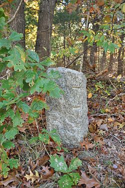
On the south side of Race Lane, just west of Trotter's Lane, at 41°41′11″N 70°26′12″W / 41.68639°N 70.43667°W / 41.68639; -70.43667 (Race Lane Marker), is a granite marker on the town line between Barnstable and Sandwich. The town line between these two towns was first laid out by the council of the Plymouth Colony in 1639, and has remained relatively stable since then. It is unknown when this rough granite marker was placed; on the street face it is marked with a B on the Barnstable side, and an S on the Sandwich side, with a carved vertical line between.[2] This marker was listed on the National Register of Historic Places in 1987 as "Town Boundary Marker".[1]
High Street marker
United States historic place
Town Line Boundary Marker | |
 | |
    | |
| Location | High Street/Old County Rd., Sandwich and Barnstable, Massachusetts |
|---|---|
| Built | 1644 |
| MPS | Barnstable MRA |
| NRHP reference No. | 87000243[1] |
| Added to NRHP | September 18, 1987 |
The High Street marker is located the north side of High Street (near #410), at 41°43′20″N 70°24′02″W / 41.722283°N 70.400687°W / 41.722283; -70.400687 (High Street Marker), on the border between Sandwich and Barnstable. Its markings are similar to those on the Race Lane marker. This area of West Barnstable was not purchased by the colonists from the local Indians until 1644; the date of this marker's placement is also unknown.[3] The marker was listed on the National Register of Historic Places as "Town Boundary Line Marker" in 1987.[1]
Great Hill Road Marker
United States historic place
Town Line Boundary Marker | |
 | |
| |
| Location | Great Hill Rd., Barnstable, Massachusetts |
|---|---|
| Area | less than one acre |
| Built | 1644 (1644) |
| MPS | Barnstable MRA |
| NRHP reference No. | 87000242[1] |
| Added to NRHP | September 18, 1987 |
The Great Hill Road marker was in 1987 located a short way north of the road's junction with Cedar Street, but these streets no longer meet. Like the High Street marker, it was probably not placed until after the area was purchased in 1644. It is marked similarly to the Race Lane and High Street markers. It was listed on the National Register in 1987 as "Town Line Boundary Marker".[1]
Main Street Marker
United States historic place
Town Boundary Marker | |
U.S. Historic district Contributing property | |
| Location | Main Street (MA 6A), Yarmouth and Barnstable, Massachusetts |
|---|---|
| Area | less than one acre |
| Part of | Old King's Highway Historic District (ID87000314[1]) |
| MPS | Barnstable MRA |
| Added to NRHP | March 12, 1987 |
The fourth marker is located on the north side of Main Street (Massachusetts Route 6A) at the Barnstable-Yarmouth line (41°42′05″N 70°15′37″W / 41.701435°N 70.260236°W / 41.701435; -70.260236 (Main Street Marker)). Unlike the others, it is a boulder-shaped marker, on which "Y+B" has been carved, with a wavy line beneath. It is believed to have been placed in the 18th century. The marker is a contributing resource to the Old King's Highway Historic District.[4]
See also
References
- ^ a b c d e f g h "National Register Information System". National Register of Historic Places. National Park Service. April 15, 2008.
- ^ a b "MACRIS inventory record for Race Lane Marker". Commonwealth of Massachusetts. Retrieved February 24, 2014.
- ^ "MACRIS inventory record for Town Boundary Marker, High Street". Commonwealth of Massachusetts. Retrieved February 24, 2014.
- ^ "MACRIS inventory record for Barnstable-Yarmouth Town Boundary Marker". Commonwealth of Massachusetts. Retrieved February 24, 2014.
- v
- t
- e

| Barnstable County | |
|---|---|
| Bristol County | |
| Essex County | |
| Hampden County | |
| Middlesex County | |
| Norfolk County | |
| Suffolk County | |
| Worcester County |
 Category
 National Register of Historic Places portal
 United States portal


