Sieg (river)
River in Germany
| Sieg | |
|---|---|
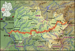 Drainage basin map of the Sieg | |
| Location | |
| Country | Germany |
| Physical characteristics | |
| Source | |
| • location | Siegerland |
| • elevation | 603 m (1,978 ft) |
| Mouth | |
• location | Rhine |
• coordinates | 50°46′7″N 7°4′32″E / 50.76861°N 7.07556°E / 50.76861; 7.07556 |
| Length | 155.1 km (96.4 mi) [1] |
| Basin size | 2,857 km2 (1,103 sq mi) [1] |
| Discharge | |
| • average | 52 m3/s (1,800 cu ft/s) |
| Basin features | |
| Progression | Rhine→ North Sea |
| Tributaries | |
| • left | Heller, Nister |
| • right | Bröl, Agger |
The Sieg (German pronunciation: [ziːk] ⓘ) is a river in North Rhine-Westphalia and Rhineland-Palatinate, Germany. It is a right tributary of the Rhine.
The river is named after the Sicambri. It is 155 kilometres (96 mi) in length.
The source is located in the Rothaargebirge mountains. From here the river runs southwestwards to the city of Siegen and the hills of Siegerland, both named after the river. Further west the Sieg valley forms the boundary of the Bergisches Land (northern) and Westerwald (southern). The river finally runs through a protected area east of the city of Bonn.
After passing the cities of Hennef and Siegburg, the river flows into the Rhine at the Naturschutzgebiet Siegaue, a protected area immediately to the northeast of the city of Bonn, near Niederkassel/Mondorf [de; ro].
Sieg Spring

The Sieg Spring (German: Siegquelle), the source of the Sieg, is at an elevation of 603 metres (1,978 ft), near the village of Großenbach [de; nl], North Rhine-Westphalia.[2] The location was restored in 2013.
Tributaries
The main tributaries of the Sieg are, from source to mouth:[1]
- Ferndorfbach (right)
- Weiß (left)
- Asdorf (right)
- Heller (left)
- Wisser Bach (right)
- Nister (left)
- Bröl (right)
- Wahnbach (right)
- Pleisbach (left)
- Agger (right)
See also
References
- ^ a b c Hydrographic Directory of the NRW State Office for Nature, the Environment and Consumer Protection (Gewässerverzeichnis des Landesamtes für Natur, Umwelt und Verbraucherschutz NRW 2010) (xls; 4.67 MB)
- ^ Topographic Information Management, Cologne - NRW GEObasis Division (info)
Wikimedia Commons has media related to Sieg.
- v
- t
- e
Tributaries of the Rhine
- Vorderrhein
- Aua da Russein
- Schmuèr
- Alpine Rhine
- Vorderrhein
- Tamina
- Alter Rhein
- Rheintaler Binnenkanal
- Upper Lake Constance
- Goldach
- Aach (Arbon)
- Aach (Romanshorn)
- Lake Rhine
- Grenzbach
- Dorfbach
- Lower Lake Constance
- Anderbach
- High Rhine
- Thur
- Töss
- Glatt
- Aare
- Sissle
- Ergolz
- Birs
- Upper Rhine
- Birsig
- Ill
- Moder
- Sauer
- Lauter
- Spiegelbach
- Queich
- Speyerbach
- Rehbach
- Isenach
- Eckbach
- Eisbach
- Pfrimm
- Selz
- Middle Rhine
- Welzbach
- Nahe
- Moselle
- Nette
- Brohlbach
- Ahr
- Lower Rhine
- Erft

- Vorderrhein
- Rein da Tuma
- Rein da Curnera
- Rein da Medel
- Rein da Sumvitg
- Glogn
- Rabiusa
- Hinterrhein
- Ragn da Ferrera
- Albula/Alvra
- Alpine Rhine
- Hinterrhein
- Plessur
- Landquart
- Mülbach
- Ill
- Frutz
- Upper Lake Constance
- Dornbirner Ach
- Bregenzer Ach
- Leiblach
- Argen
- Schussen
- Rotach
- Brunnisach
- Lipbach
- Seefelder Aach
- Stockacher Aach
- Lower Lake Constance
- Radolfzeller Aach
- High Rhine
- Biber
- Durach
- Wutach
- Alb
- Murg
- Wehra
- Upper Rhine
- Wiese
- Kander
- Elz
- Kinzig
- Rench
- Acher
- Murg
- Alb
- Pfinz
- Saalbach
- Kraichbach
- Leimbach
- Neckar
- Weschnitz
- Modau
- Main
- Middle Rhine
- Wisper
- Lahn
- Wied
- Lower Rhine
- Sieg
- Wupper
- Düssel
- Ruhr
- Emscher
- Lippe
- IJssel
- Oude IJssel/Issel
- Berkel
- Schipbeek
| |
|---|---|
| Baltic Sea |
|
| Black Sea |
|
| North Sea | |
| Maas | |
| |


Authority control databases | |
|---|---|
| International |
|
| National |
|
This article related to a river in North Rhine-Westphalia is a stub. You can help Wikipedia by expanding it. |
- v
- t
- e
This article related to a river in Rhineland-Palatinate is a stub. You can help Wikipedia by expanding it. |
- v
- t
- e


