Sørkapp Land
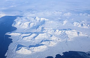
Sørkapp Land is the land area south of Hornsund, at the southern part of Spitsbergen, Svalbard.[1] Two glaciers, Hornbreen and Hambergbreen, divide Sørkapp Land from Torell Land.[2][3]
Sørkapp Land is included in the Sør-Spitsbergen National Park.
References
- ^ "Sørkapp Land". Norwegian Polar Institute. Retrieved 15 November 2011.
- ^ "Hornbreen". Norwegian Polar Institute. Archived from the original on 11 July 2012. Retrieved 15 November 2011.
- ^ "Hambergbreen". Norwegian Polar Institute. Archived from the original on 16 July 2012. Retrieved 15 November 2011.
- v
- t
- e
Svalbard
- Agriculture
- Archaeology
- Cannabis
- Outline
- Economy
- Geography
- Newtontoppen
- History
- Languages
- Museums
- Transport
- In fiction
- Amsterdam Island
- Barentsøya
- Bear Island
- Danes Island
- Edgeøya
- Hopen
- Kong Karls Land
- Kongsøya
- Kvitøya
- Lågøya
- Nordaustlandet
- Prins Karls Forland
- Sjuøyane
- Spitsbergen
- Svenskøya
- Thousand Islands
- Wilhelm Island
- Spitsbergen
- Albert I Land
- Andrée Land
- Bünsow Land
- Dickson Land
- Haakon VII Land
- Heer Land
- James I Land
- Nathorst Land
- Nordenskiöld Land
- Ny-Friesland
- Olav V Land
- Oscar II Land
- Sabine Land
- Sørkapp Land
- Torell Land
- Wedel Jarlsberg Land
- Nordaustlandet
- Gustav Adolf Land
- Gustav V Land
- Orvin Land
- Arctic Coal Company
- Arktikugol
- Bjørnøen
- Kings Bay
- Store Norske
- Arctic World Archive
- Amundsen-Nobile Climate Change Tower
- Arctic Yellow River Station
- Dirigibile Italia Arctic Station
- Himadri Station
- IndARC Station
- Norwegian Polar Institute
- Polish Polar Station
- Seed Vault
- University Centre
- Zeppelin Station
76°48′00″N 16°45′00″E / 76.8000°N 16.7500°E / 76.8000; 16.7500
 | This Spitsbergen location article is a stub. You can help Wikipedia by expanding it. |
- v
- t
- e


