Riksa Islands
62°23′05″S 59°46′49″W / 62.38472°S 59.78028°W / -62.38472; -59.78028
Antarctica
Riksa Islands (Bulgarian: острови Рикса, ‘Ostrovi Riksa’ \'os-trovi 'ri-ksa\) are three adjacent ice-free islands in the Aitcho group on the west side of English Strait in the South Shetland Islands, Antarctica.[1] The islands are situated 250 m (270 yd) west of Bilyana Island, 650 m (710 yd) northeast of Emeline Island and 2.1 km (1.3 mi) east of Holmes Rock. The area was visited by early 19th century sealers.
The group comprises the islands of Cricklewood (62°23′05″S 59°46′27″W / 62.38472°S 59.77417°W / -62.38472; -59.77417), Taunton (62°23′03″S 59°46′56″W / 62.38417°S 59.78222°W / -62.38417; -59.78222) and Bath (62°22′53″S 59°47′19″W / 62.38139°S 59.78861°W / -62.38139; -59.78861).[2][3][4]
Riksa Islands are named after the settlements of Kamenna (Stone) Riksa and Lower Riksa in northwestern Bulgaria. Cricklewood Island is named after the district of London where the main part of the UKHO was located until 1968. Taunton Island is named after the town of Taunton in England, where the UKHO printing works has been located since 1941 and where the remainder of the Office moved in 1968. Bath Island is named after the city of Bath in England, where sections of the UKHO were temporarily located during World War II.
Location
The islands are located at 62°23′05″S 59°46′49″W / 62.38472°S 59.78028°W / -62.38472; -59.78028. Bulgarian mapping in 2009.
See also
- Composite Gazetteer of Antarctica
- List of Antarctic islands south of 60° S
- SCAR
- Territorial claims in Antarctica
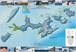
Map
- L.L. Ivanov. Antarctica: Livingston Island and Greenwich, Robert, Snow and Smith Islands. Scale 1:120000 topographic map. Troyan: Manfred Wörner Foundation, 2010. ISBN 978-954-92032-9-5 (First edition 2009. ISBN 978-954-92032-6-4)
- Antarctic Digital Database (ADD). Scale 1:250000 topographic map of Antarctica. Scientific Committee on Antarctic Research (SCAR). Since 1993, regularly upgraded and updated.
- L.L. Ivanov. Antarctica: Livingston Island and Smith Island. Scale 1:100000 topographic map. Manfred Wörner Foundation, 2017. ISBN 978-619-90008-3-0
Notes
- ^ Riksa Islands. SCAR Composite Antarctic Gazetteer.
- ^ Cricklewood Island. SCAR Composite Antarctic Gazetteer.
- ^ Taunton Island. SCAR Composite Antarctic Gazetteer.
- ^ Bath Island. SCAR Composite Antarctic Gazetteer.
References
- Bulgarian Antarctic Gazetteer. Antarctic Place-names Commission. (details in Bulgarian, basic data in English)
External links
- Riksa Islands. Copernix satellite image
This article includes information from the Antarctic Place-names Commission of Bulgaria which is used with permission.
Portals:
 Islands
 Geography


- v
- t
- e
- Clarence
- Deception
- Elephant
- Greenwich
- King George
- Livingston
- Low
- Nelson
- Robert
- Smith
- Snow
- Afala
- Aitcho
- Akin
- Alfeus
- Araguez
- Astor
- Aurelia
- Barlow
- Basso
- Beslen
- Biruni
- Boatin
- Borceguí
- Bridgeman
- Cacho
- Chiprovtsi
- Cornwall
- Cornwallis
- Craggy
- Dee
- Desolation Island (South Shetland Islands)
- Dinea
- Dioptra
- Dufayel
- Dunbar
- Eadie
- Express
- Fregata
- Gergini
- Gibbs
- Glumche
- Gnomon
- González
- Half Moon
- Heywood
- Kabile
- Kaliman
- Kondor
- Korsis
- Låvebrua
- Meade
- Miladinovi
- Montufar
- Ogygia
- Ongley
- Onogur
- Penguin
- Pindarev
- Pordim
- Presnakov
- Prisad
- Prosechen
- Pyramid
- Rogozen
- Romeo
- Rotalia
- Rowett
- Rugged
- Saffar
- San Telmo
- Seal
- Sierra
- Square End
- Stoker
- Sugarloaf
- Table
- Tatul
- Tirizis
- Toledo
- Treklyano
- Two Summit
- Valchedram
- Window
- Withem
- Wood
- Yrvind
- Zebil
- Zed
Rocks, stacks, reefs
spits and banks
spits and banks
- Aim Rocks
- Alepu
- Avren
- Baktriana
- Ballestilla
- Bekas
- Belchin
- Besson
- Bizone
- Bonert
- Borda
- Bowler
- Brahe
- Bris
- Buchino
- Caraquet
- Chabrier
- Channel
- Chaos
- Chapman
- Cheshire
- Chorobates
- Cone
- Cosmolabe
- Cove
- Cutler
- Dlagnya
- Dovizio
- Dzhegov
- Eddystone
- Elemag
- Eliza
- Emm
- Enchantress
- Folger
- Frederick
- Galiche
- Goritsa
- Grace
- Graovo
- Groma
- Growler
- Habermehl
- Hauken
- Henfield
- Hetty
- Hole
- Holmes
- Ibar
- Indian
- Keep
- Kianida
- Knight
- Koynare
- Lenoir
- Letelier
- Liberty
- Lientur
- Limit
- Livonia
- Long
- Low
- Lynx
- Lyutibrod
- Maglizh
- Makresh
- Martello Tower
- Meldia
- Mellona
- Milev
- Mónica
- Morris
- Nancy
- Napier
- Nessie
- Nikudin
- Odometer
- Okol
- Opaka
- Ørnen
- Orsini
- Orsoya
- Parry Patch
- Passage
- Patresh
- Perivol
- Pig
- Pingvin
- Potmess
- Asses Ears
- Priboy
- Rabisha
- Ramsden
- Raquelia
- Reyes
- Ritchie
- Rongel
- Rosales
- Rusokastro
- Sail Rock
- Salient
- Sally
- Sewing-Machine Needles
- Shearer
- Simms
- Simpson
- Sinbad
- Skrino
- Stackpole
- Stewart
- Suhache
- Syrezol
- Telefon
- Telish
- Tenorio
- The Pointers
- Tooth
- Triznatsi
- Troughton
- Tu
- Turmoil
- Tvarditsa
- Twin Pinnacles
- Upton
- Vardim
- Vergilov
- Vidal
- Vietor
- Vodoley
- Voluyak
- Waldseemüller
- Weeks
Undersea and
subglacial features
subglacial features
| ||||||||
|---|---|---|---|---|---|---|---|---|
| Geography |
|  | ||||||
| History | ||||||||
| Politics | ||||||||
| Society | ||||||||
| Famous explorers | ||||||||
| ||||||||

 | This Greenwich Island location article is a stub. You can help Wikipedia by expanding it. |
- v
- t
- e


