National Register of Historic Places listings in San Joaquin County, California

This is a list of the National Register of Historic Places listings in San Joaquin County, California.
This is intended to be a complete list of the properties and districts on the National Register of Historic Places in San Joaquin County, California, United States. Latitude and longitude coordinates are provided for many National Register properties and districts; these locations may be seen together in an online map.[1]
There are 36 properties and districts listed on the National Register in the county.
This National Park Service list is complete through NPS recent listings posted June 14, 2024.[2]
Map all coordinates using OpenStreetMap
Download coordinates as:
- KML
- GPX (all coordinates)
- GPX (primary coordinates)
- GPX (secondary coordinates)
Current listings
| [3] | Name on the Register[4] | Image | Date listed[5] | Location | City or town | Description |
|---|---|---|---|---|---|---|
| 1 | Bank of Italy |  | July 18, 1985 (#85001591) | 628 Central Ave. 37°44′08″N 121°25′28″W / 37.735556°N 121.424444°W / 37.735556; -121.424444 (Bank of Italy) | Tracy | |
| 2 | Bank of Tracy |  | June 3, 1980 (#80000851) | 803 Central Ave. 37°44′13″N 121°25′29″W / 37.736944°N 121.424722°W / 37.736944; -121.424722 (Bank of Tracy) | Tracy | |
| 3 | Cole's Five Cypress Farm | Upload image | May 25, 1988 (#88000578) | 11221 E. Eight Mile Rd. 38°03′39″N 121°10′57″W / 38.060833°N 121.1825°W / 38.060833; -121.1825 (Cole's Five Cypress Farm) | Stockton | |
| 4 | Commercial and Savings Bank |  | November 25, 1980 (#80000849) | 343 Main St. 37°57′13″N 121°17′01″W / 37.953611°N 121.283611°W / 37.953611; -121.283611 (Commercial and Savings Bank) | Stockton | |
| 5 | El Dorado Elementary School |  | August 15, 1977 (#77000335) | 1525 Pacific Avenue[6] 37°58′02″N 121°17′54″W / 37.967222°N 121.298333°W / 37.967222; -121.298333 (El Dorado Elementary School) | Stockton | Now used as the Stockton School for Adults |
| 6 | Elks Building |  | June 3, 1980 (#80004606) | 42 N. Sutter St. 37°57′48″N 121°17′05″W / 37.963333°N 121.284722°W / 37.963333; -121.284722 (Elks Building) | Stockton | |
| 7 | Farmer's and Merchant's Bank | 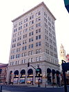 | October 9, 1980 (#80000850) | 11 S. San Joaquin St. 37°57′11″N 121°17′12″W / 37.953056°N 121.286667°W / 37.953056; -121.286667 (Farmer's and Merchant's Bank) | Stockton | |
| 8 | Fox California Theater |  | June 27, 1979 (#79000540) | 242 E. Main St. 37°57′09″N 121°17′12″W / 37.9525°N 121.286667°W / 37.9525; -121.286667 (Fox California Theater) | Stockton | |
| 9 | Wong K. Gew Mansion |  | September 20, 1978 (#78000761) | 345 W. Clay St. 37°56′21″N 121°17′29″W / 37.939167°N 121.291389°W / 37.939167; -121.291389 (Wong K. Gew Mansion) | Stockton | |
| 10 | Harmony Grove Church |  | January 3, 2011 (#10001103) | 11455 E. Locke Rd. 38°08′50″N 121°10′34″W / 38.147222°N 121.176111°W / 38.147222; -121.176111 (Harmony Grove Church) | Lockeford | |
| 11 | Benjamin Holt House |  | March 2, 1982 (#82002254) | 548 Park St. 37°57′37″N 121°17′04″W / 37.960278°N 121.284444°W / 37.960278; -121.284444 (Benjamin Holt House) | Stockton | |
| 12 | Hotel Lodi | 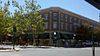 | September 29, 1995 (#95001140) | 5 S. School St. 38°08′02″N 121°16′24″W / 38.133889°N 121.273333°W / 38.133889; -121.273333 (Hotel Lodi) | Lodi | |
| 13 | Hotel Stockton |  | April 1, 1981 (#81000174) | 133 E. Weber Ave. 37°57′15″N 121°17′18″W / 37.954167°N 121.288333°W / 37.954167; -121.288333 (Hotel Stockton) | Stockton | |
| 14 | I.O.O.F. Hall | 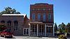 | April 22, 1982 (#82002257) | Main St. 38°09′17″N 121°17′59″W / 38.154722°N 121.299722°W / 38.154722; -121.299722 (I.O.O.F. Hall) | Woodbridge | |
| 15 | IOOF Lodge No. 355 | Upload image | March 1, 2007 (#07000085) | 18819 East CA 88 38°11′30″N 121°05′06″W / 38.191667°N 121.085°W / 38.191667; -121.085 (IOOF Lodge No. 355) | Clements | |
| 16 | Locke House and Barn | Upload image | June 19, 1972 (#72000252) | 19960 W. Elliott Rd. 38°09′53″N 121°08′59″W / 38.164722°N 121.149722°W / 38.164722; -121.149722 (Locke House and Barn) | Lockeford | |
| 17 | Locke's Meat Market |  | February 19, 1982 (#82002253) | 13480 CA 88 38°09′48″N 121°08′57″W / 38.163333°N 121.149167°W / 38.163333; -121.149167 (Locke's Meat Market) | Lockeford | |
| 18 | Lodi Arch |  | September 17, 1980 (#80000848) | Pine St. 38°08′03″N 121°16′15″W / 38.134167°N 121.270833°W / 38.134167; -121.270833 (Lodi Arch) | Lodi | |
| 19 | Morse-Skinner Ranch House | Upload image | August 21, 1986 (#86001878) | 13063 N. CA 99 38°05′51″N 121°15′35″W / 38.0975°N 121.259722°W / 38.0975; -121.259722 (Morse-Skinner Ranch House) | Lodi | |
| 20 | Nippon Hospital |  | September 18, 1978 (#78000762) | 25 S. Commerce St. 37°57′07″N 121°17′30″W / 37.951944°N 121.291667°W / 37.951944; -121.291667 (Nippon Hospital) | Stockton | |
| 21 | John Ohm House |  | February 4, 1982 (#82002256) | 31524 S. Kasson Rd. 37°40′04″N 121°15′39″W / 37.667778°N 121.260833°W / 37.667778; -121.260833 (John Ohm House) | Tracy | |
| 22 | Old Weber School | 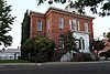 | July 16, 1973 (#73000445) | 55 W. Flora St. 37°57′38″N 121°17′36″W / 37.960556°N 121.293333°W / 37.960556; -121.293333 (Old Weber School) | Stockton | |
| 23 | Philomathean Clubhouse |  | January 5, 2009 (#08001278) | 1000 North Hunter Street 37°57′47″N 121°17′28″W / 37.963056°N 121.291111°W / 37.963056; -121.291111 (Philomathean Clubhouse) | Stockton | |
| 24 | Moses Rodgers House | 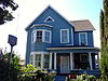 | April 26, 1978 (#78000763) | 921 S. San Joaquin St. 37°56′37″N 121°17′02″W / 37.943611°N 121.283889°W / 37.943611; -121.283889 (Moses Rodgers House) | Stockton | |
| 25 | Sperry Office Building |  | February 19, 1982 (#82002255) | 146 W. Weber Ave. 37°57′10″N 121°17′35″W / 37.952778°N 121.293056°W / 37.952778; -121.293056 (Sperry Office Building) | Stockton | |
| 26 | Sperry Union Flour Mill |  | January 31, 1979 (#79000541) | 445 W. Weber 37°57′11″N 121°17′44″W / 37.953056°N 121.295556°W / 37.953056; -121.295556 (Sperry Union Flour Mill) | Stockton | |
| 27 | Stockton Savings and Loan Society Bank |  | October 19, 1978 (#78000764) | 301 E. Main St. 37°57′13″N 121°17′09″W / 37.953611°N 121.285833°W / 37.953611; -121.285833 (Stockton Savings and Loan Society Bank) | Stockton | |
| 28 | Terminous Culling Chute | Upload image | April 19, 1984 (#84001189) | 14900 W. CA 12 38°06′35″N 121°29′57″W / 38.109722°N 121.499167°W / 38.109722; -121.499167 (Terminous Culling Chute) | Lodi | |
| 29 | Tracy City Hall and Jail |  | October 18, 1979 (#79000542) | 25 W. 7th St. 37°44′09″N 121°25′31″W / 37.735833°N 121.425278°W / 37.735833; -121.425278 (Tracy City Hall and Jail) | Tracy | |
| 30 | Tracy Inn |  | October 31, 1980 (#80000852) | 24 W. 11th St. 37°44′22″N 121°25′31″W / 37.739444°N 121.425278°W / 37.739444; -121.425278 (Tracy Inn) | Tracy | |
| 31 | Tretheway Block |  | October 29, 1982 (#82000987) | 229 E. Weber St. 37°57′06″N 121°17′14″W / 37.951667°N 121.287222°W / 37.951667; -121.287222 (Tretheway Block) | Stockton | |
| 32 | USCGC Fir | 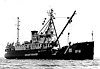 | April 27, 1992 (#92001880) | Coordinates missing | Stockton | Listed in Seattle, but is actually in California. |
| 33 | U.S. Post Office |  | February 10, 1983 (#83001236) | 401 N. San Joaquin St. 37°57′27″N 121°17′17″W / 37.9575°N 121.288056°W / 37.9575; -121.288056 (U.S. Post Office) | Stockton | |
| 34 | West Side Bank |  | December 12, 1978 (#78000765) | 47 W. 6th St. 37°44′06″N 121°25′32″W / 37.735°N 121.425556°W / 37.735; -121.425556 (West Side Bank) | Tracy | |
| 35 | Woman's Club of Lodi |  | May 20, 1988 (#88000555) | 325 W. Pine St. 38°08′05″N 121°16′34″W / 38.134722°N 121.276111°W / 38.134722; -121.276111 (Woman's Club of Lodi) | Lodi | |
| 36 | Woodbridge Masonic Lodge No. 131 |  | April 20, 1989 (#89000318) | 1040 Augusta St. 38°09′14″N 121°18′03″W / 38.153889°N 121.300833°W / 38.153889; -121.300833 (Woodbridge Masonic Lodge No. 131) | Woodbridge |
See also
Wikimedia Commons has media related to National Register of Historic Places in San Joaquin County, California.
- List of National Historic Landmarks in California
- National Register of Historic Places listings in California
- California Historical Landmarks in San Joaquin County, California
References
- ^ The latitude and longitude information provided in this table was derived originally from the National Register Information System, which has been found to be fairly accurate for about 99% of listings. Some locations in this table may have been corrected to current GPS standards.
- ^ National Park Service, United States Department of the Interior, "National Register of Historic Places: Weekly List Actions", retrieved June 14, 2024.
- ^ Numbers represent an alphabetical ordering by significant words. Various colorings, defined here, differentiate National Historic Landmarks and historic districts from other NRHP buildings, structures, sites or objects.
- ^ "National Register Information System". National Register of Historic Places. National Park Service. July 9, 2010.
- ^ The eight-digit number below each date is the number assigned to each location in the National Register Information System database, which can be viewed by clicking the number.
- ^ "School for Adults". Stockton Unified School District. Retrieved April 23, 2016.
- v
- t
- e
- List of U.S. National Historic Landmarks by state:
- Alabama
- Alaska
- Arizona
- Arkansas
- California
- Colorado
- Connecticut
- Delaware
- Florida
- Georgia
- Hawaii
- Idaho
- Illinois
- Indiana
- Iowa
- Kansas
- Kentucky
- Louisiana
- Maine
- Maryland
- Massachusetts
- Michigan
- Minnesota
- Mississippi
- Missouri
- Montana
- Nebraska
- Nevada
- New Hampshire
- New Jersey
- New Mexico
- New York
- North Carolina
- North Dakota
- Ohio
- Oklahoma
- Oregon
- Pennsylvania
- Rhode Island
- South Carolina
- South Dakota
- Tennessee
- Texas
- Utah
- Vermont
- Virginia
- Washington
- West Virginia
- Wisconsin
- Wyoming
 National Register of Historic Places portal
 Category


Municipalities and communities of San Joaquin County, California, United States | ||
|---|---|---|
County seat: Stockton | ||
| Cities |  | |
| Census-designated places | ||
| Unincorporated communities | ||
| Ghost towns | ||
| ||


