National Register of Historic Places listings in Imperial County, California

This is a list of the National Register of Historic Places listings in Imperial County, California.
This is intended to be a complete list of the properties and districts on the National Register of Historic Places in Imperial County, California, United States. Latitude and longitude coordinates are provided for many National Register properties and districts; these locations may be seen together in a Google map.[1]
There are 12 properties and districts listed on the National Register in the county, including 1 National Historic Landmark.
This National Park Service list is complete through NPS recent listings posted June 14, 2024.[2]
Map all coordinates using OpenStreetMap
Download coordinates as:
- KML
- GPX (all coordinates)
- GPX (primary coordinates)
- GPX (secondary coordinates)
Current listings
| [3] | Name on the Register[4] | Image | Date listed[5] | Location | City or town | Description |
|---|---|---|---|---|---|---|
| 1 | Calexico Carnegie Library |  | September 28, 2005 (#05001085) | 420 Heber Ave. 32°40′10″N 115°29′33″W / 32.669444°N 115.4925°W / 32.669444; -115.4925 (Calexico Carnegie Library) | Calexico | |
| 2 | Desert View Tower | 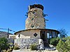 | August 29, 1980 (#80000801) | SW of Ocotillo 32°39′33″N 116°05′57″W / 32.659167°N 116.099167°W / 32.659167; -116.099167 (Desert View Tower) | Ocotillo | |
| 3 | Fages-De Anza Trail-Southern Emigrant Road |  | January 29, 1973 (#73002252) | Anza-Borrego State Park Coordinates missing | Borrego Springs | |
| 4 | Southwest Lake Cahuilla Recessional Shoreline Archeological District | Upload image | December 30, 1999 (#99001567) | Address Restricted | Salton City | Archeological sites along shoreline of former Lake Cahuilla |
| 5 | Spoke Wheel Rock Alignment | Upload image | September 29, 2003 (#03000120) | Address Restricted | Ocotillo | |
| 6 | Stonehead (L-7) | Upload image | May 1, 1987 (#87001026) | Address Restricted | Yuma | |
| 7 | US Inspection Station-Calexico | 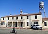 | February 14, 1992 (#91001749) | 12 Heffernan Ave. 32°39′55″N 115°29′41″W / 32.665139°N 115.494847°W / 32.665139; -115.494847 (US Inspection Station-Calexico) | Calexico | |
| 8 | US Post Office-El Centro Main |  | January 11, 1985 (#85000125) | 230 S. 5th St. 32°47′27″N 115°33′14″W / 32.790833°N 115.553889°W / 32.790833; -115.553889 (US Post Office-El Centro Main) | El Centro | |
| 9 | Winterhaven Anthropomorph (L-8) | Upload image | May 1, 1987 (#87001025) | Address Restricted | Yuma | |
| 10 | Winterhaven Anthropomorph and Bowknot, L-9 | Upload image | October 25, 1985 (#85003429) | Address Restricted | Winterhaven | |
| 11 | Yuha Basin Discontiguous District | Upload image | May 24, 1982 (#82002185) | Address Restricted | Plaster City | |
| 12 | Yuma Crossing and Associated Sites | 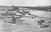 | November 13, 1966 (#66000197) | Banks of the Colorado River 32°43′48″N 114°37′05″W / 32.73°N 114.618056°W / 32.73; -114.618056 (Yuma Crossing and Associated Sites) | Winterhaven |
See also
Wikimedia Commons has media related to National Register of Historic Places in Imperial County, California.
- List of National Historic Landmarks in California
- National Register of Historic Places listings in California
- California Historical Landmarks in Imperial County, California
References
- ^ The latitude and longitude information provided in this table was derived originally from the National Register Information System, which has been found to be fairly accurate for about 99% of listings. Some locations in this table may have been corrected to current GPS standards.
- ^ National Park Service, United States Department of the Interior, "National Register of Historic Places: Weekly List Actions", retrieved June 14, 2024.
- ^ Numbers represent an alphabetical ordering by significant words. Various colorings, defined here, differentiate National Historic Landmarks and historic districts from other NRHP buildings, structures, sites or objects.
- ^ "National Register Information System". National Register of Historic Places. National Park Service. July 9, 2010.
- ^ The eight-digit number below each date is the number assigned to each location in the National Register Information System database, which can be viewed by clicking the number.
- v
- t
- e
- List of U.S. National Historic Landmarks by state:
- Alabama
- Alaska
- Arizona
- Arkansas
- California
- Colorado
- Connecticut
- Delaware
- Florida
- Georgia
- Hawaii
- Idaho
- Illinois
- Indiana
- Iowa
- Kansas
- Kentucky
- Louisiana
- Maine
- Maryland
- Massachusetts
- Michigan
- Minnesota
- Mississippi
- Missouri
- Montana
- Nebraska
- Nevada
- New Hampshire
- New Jersey
- New Mexico
- New York
- North Carolina
- North Dakota
- Ohio
- Oklahoma
- Oregon
- Pennsylvania
- Rhode Island
- South Carolina
- South Dakota
- Tennessee
- Texas
- Utah
- Vermont
- Virginia
- Washington
- West Virginia
- Wisconsin
- Wyoming
 National Register of Historic Places portal
 Category


Municipalities and communities of Imperial County, California, United States | ||
|---|---|---|
County seat: El Centro | ||
| Cities |  | |
| CDPs |
| |
| Unincorporated communities | ||
| Indian reservations | ||
| Ghost towns | ||
| Footnotes | ‡This populated place also has portions in an adjacent county or counties | |
| ||


