National Register of Historic Places listings in Gregory County, South Dakota

This is a list of the National Register of Historic Places listings in Gregory County, South Dakota.
This is intended to be a complete list of the properties and districts on the National Register of Historic Places in Gregory County, South Dakota, United States. The locations of National Register properties and districts for which the latitude and longitude coordinates are included below, may be seen in a map.[1]
There are 12 properties and districts listed on the National Register in the county. Another 2 properties were once listed but have been removed.
This National Park Service list is complete through NPS recent listings posted June 14, 2024.[2]
Map all coordinates using OpenStreetMap
Download coordinates as:
- KML
- GPX (all coordinates)
- GPX (primary coordinates)
- GPX (secondary coordinates)
Current listings
| [3] | Name on the Register[4] | Image | Date listed[5] | Location | City or town | Description |
|---|---|---|---|---|---|---|
| 1 | Dallas Carnegie Library | 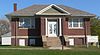 | May 28, 1976 (#76001734) | 405 Main St. 43°14′10″N 99°31′01″W / 43.2360°N 99.5170°W / 43.2360; -99.5170 (Dallas Carnegie Library) | Dallas | |
| 2 | Fort Randall |  | April 22, 1976 (#76001735) | 3 miles southwest of Pickstown 43°02′51″N 98°33′32″W / 43.0475°N 98.5589°W / 43.0475; -98.5589 (Fort Randall) | Pickstown | |
| 3 | Gregory Buttes Stone Steps |  | July 28, 2004 (#04000763) | 200 and 300 blocks of 11th-14th Sts. 43°14′23″N 99°26′04″W / 43.2398°N 99.4344°W / 43.2398; -99.4344 (Gregory Buttes Stone Steps) | Gregory | |
| 4 | Gregory County Courthouse | Upload image | February 4, 2021 (#100006095) | 221 East 8th St. 43°10′56″N 99°17′24″W / 43.1821°N 99.2900°W / 43.1821; -99.2900 (Gregory County Courthouse) | Burke | |
| 5 | Gregory County State Bank | 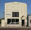 | November 19, 1998 (#98001399) | Main St. at its junction with Randall St. 43°01′39″N 98°53′19″W / 43.0276°N 98.8887°W / 43.0276; -98.8887 (Gregory County State Bank) | Fairfax | |
| 6 | Gregory National Bank |  | July 30, 2013 (#13000573) | 524 Main St 43°13′56″N 99°25′52″W / 43.2321°N 99.4310°W / 43.2321; -99.4310 (Gregory National Bank) | Gregory | |
| 7 | Herrick Elevator | 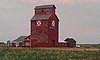 | May 30, 2003 (#03000498) | U.S. Route 18 43°07′26″N 99°10′58″W / 43.1239°N 99.1828°W / 43.1239; -99.1828 (Herrick Elevator) | Herrick | |
| 8 | Herrick Public School |  | August 16, 2000 (#00001000) | 450 8th St. 43°07′08″N 99°11′21″W / 43.1189°N 99.1891°W / 43.1189; -99.1891 (Herrick Public School) | Herrick | |
| 9 | Pocahontas Schoolhouse |  | April 26, 1973 (#73001743) | Near 5th and Main[6] 43°13′53″N 99°25′48″W / 43.2314°N 99.4301°W / 43.2314; -99.4301 (Pocahontas Schoolhouse) | Gregory | |
| 10 | St. Augustine Church | 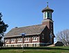 | November 20, 2009 (#09000944) | Southeastern corner of the junction of 6th and Main Sts. 43°14′02″N 99°31′02″W / 43.2339°N 99.5171°W / 43.2339; -99.5171 (St. Augustine Church) | Dallas | |
| 11 | St. John's Catholic Church |  | November 20, 2009 (#09000945) | Section 31 R96W 73N of Dickens Township, near Dallas 43°04′57″N 99°32′00″W / 43.0824°N 99.5333°W / 43.0824; -99.5333 (St. John's Catholic Church) | Paxton | |
| 12 | Tackett Underwood Building | 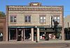 | June 3, 1999 (#99000678) | 518 and 520 Main 43°13′55″N 99°25′52″W / 43.2319°N 99.4311°W / 43.2319; -99.4311 (Tackett Underwood Building) | Gregory |
Former listings
| [3] | Name on the Register | Image | Date listed | Date removed | Location | City or town | Description |
|---|---|---|---|---|---|---|---|
| 1 | South Dakota Department of Transportation Bridge No. 27-000-201 | Upload image | December 9, 1993 (#93001289) | March 26, 2008 | Local road over unnamed creek | Dallas vicinity | |
| 2 | South Dakota Department of Transportation Bridge No. 27-060-298 | Upload image | December 9, 1993 (#93001290) | December 15, 1999 | Gregory vicinity |
See also
Wikimedia Commons has media related to National Register of Historic Places in Gregory County, South Dakota.
- List of National Historic Landmarks in South Dakota
- National Register of Historic Places listings in South Dakota
References
- ^ The latitude and longitude information provided in this table was derived originally from the National Register Information System, which has been found to be fairly accurate for about 99% of listings. Some locations in this table may have been corrected to current GPS standards.
- ^ National Park Service, United States Department of the Interior, "National Register of Historic Places: Weekly List Actions", retrieved June 14, 2024.
- ^ a b Numbers represent an alphabetical ordering by significant words. Various colorings, defined here, differentiate National Historic Landmarks and historic districts from other NRHP buildings, structures, sites or objects.
- ^ "National Register Information System". National Register of Historic Places. National Park Service. April 24, 2008.
- ^ The eight-digit number below each date is the number assigned to each location in the National Register Information System database, which can be viewed by clicking the number.
- ^ See photo.
- v
- t
- e

county
- Aurora
- Beadle
- Bennett
- Bon Homme
- Brookings
- Brown
- Brule
- Buffalo
- Butte
- Campbell
- Charles Mix
- Clark
- Clay
- Codington
- Corson
- Custer
- Davison
- Day
- Deuel
- Dewey
- Douglas
- Edmunds
- Fall River
- Faulk
- Grant
- Gregory
- Haakon
- Hamlin
- Hand
- Hanson
- Harding
- Hughes
- Hutchinson
- Hyde
- Jackson
- Jerauld
- Jones
- Kingsbury
- Lake
- Lawrence
- Lincoln
- Lyman
- Marshall
- McCook
- McPherson
- Meade
- Mellette
- Miner
- Minnehaha
- Moody
- Oglala Lakota
- Pennington
- Perkins
- Potter
- Roberts
- Sanborn
- Spink
- Stanley
- Sully
- Todd
- Tripp
- Turner
- Union
- Walworth
- Yankton
- Ziebach
 Category
 List
List National Register of Historic Places Portal


Municipalities and communities of Gregory County, South Dakota, United States | ||
|---|---|---|
County seat: Burke | ||
| Cities | 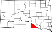 | |
| Towns | ||
| CDP | ||
| Other communities | ||
| Indian reservation | ||
| Footnotes | ‡This populated place also has portions in an adjacent county or counties | |
| ||


