Kráľová pri Senci
Municipality in Slovakia
48°12′N 17°27′E / 48.200°N 17.450°E / 48.200; 17.450 (2021)
900 50[3]
Kráľová pri Senci (Hungarian: Királyfa, meaning King Tree) is a village and municipality in western Slovakia in Senec District in the Bratislava Region.
History
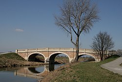
The village was first mentioned in 1363, it was royal property, hence probably the name. The most significant landmark of village is secession bridge over the river Čierna voda, which was built in 1904 and it imitates baroque architecture.
Geography
The village lies at an altitude of 128 metres and covers an area of 19.912 km². It has a population of 1426 people (as of 2004).
References
- ^ "Počet obyvateľov podľa pohlavia - obce (ročne)". www.statistics.sk (in Slovak). Statistical Office of the Slovak Republic. 2022-03-31. Retrieved 2022-03-31.
- ^ a b "Hustota obyvateľstva - obce [om7014rr_ukaz: Rozloha (Štvorcový meter)]". www.statistics.sk (in Slovak). Statistical Office of the Slovak Republic. 2022-03-31. Retrieved 2022-03-31.
- ^ a b c d "Základná charakteristika". www.statistics.sk (in Slovak). Statistical Office of the Slovak Republic. 2015-04-17. Retrieved 2022-03-31.
- ^ a b "Hustota obyvateľstva - obce". www.statistics.sk (in Slovak). Statistical Office of the Slovak Republic. 2022-03-31. Retrieved 2022-03-31.
External links
![]() Media related to Kráľová pri Senci at Wikimedia Commons
Media related to Kráľová pri Senci at Wikimedia Commons
- Municipal website (in Slovak)
- https://web.archive.org/web/20080111223415/http://www.statistics.sk/mosmis/eng/run.html
- v
- t
- e
Municipalities of Senec District
- Senec
- Bernolákovo
- Blatné
- Boldog
- Čataj
- Chorvátsky Grob
- Dunajská Lužná
- Hamuliakovo
- Hrubá Borša
- Hrubý Šúr
- Hurbanova Ves
- Igram
- Ivanka pri Dunaji
- Kalinkovo
- Kaplna
- Kostolná pri Dunaji
- Kráľová pri Senci
- Malinovo
- Miloslavov
- Most pri Bratislave
- Nová Dedinka
- Nový Svet
- Reca
- Rovinka
- Tomášov
- Tureň
- Veľký Biel
- Vlky
- Zálesie

| Authority control databases |
|
|---|
 | This Bratislava location article is a stub. You can help Wikipedia by expanding it. |
- v
- t
- e


