Coffin Bay National Park
Protected area in South Australia
34°40′25″S 135°25′48″E / 34.6737°S 135.4301°E / -34.6737; 135.4301[1]Coffin Bay National Park is a protected area in on the Eyre Peninsula of South Australia, Australia, which is located about 301 km west of Adelaide and about 46 km west of Port Lincoln. The town of Coffin Bay is near the entrance to the national park. The national park occupies the Coffin Bay Peninsula - a long peninsula with a sheltered bay to its north, coastal dunes, swamps and a coastline which overlooks islands, reefs, limestone cliffs and white surf beaches.
To the east of Point Avoid are Almonta and Gunyah Beaches, used for surfing. Reefs extend out to sea from Point Avoid to Golden Island with Price Island further out. There is a camping area at Yangie Bay with camping fees payable on entry to the National Park. Access to the majority of the park's area north of Yangie Bay is via four wheel drive tracks only.
The historic former Coffin Bay Whaling Site at Point Sir Isaac lies within the national park and is listed on the South Australian Heritage Register.[4]
Wildlife
There is a great variety of wildlife in the national park. Many seabirds can be seen including white-bellied sea eagles and ospreys as well as various albatrosses and petrels.
The volunteer organisation Friends of Coffin Bay Parks have worked to re-introduce native plants and eradicate feral animals and weeds.
Associated protected areas
Statutory
The waters adjoining the coastline of the national park are within the Thorny Passage Marine Park.[5]
Non-statutory arrangements
The area covered by the national park is also overlapped by the Coffin Bay Important Bird Area, a non-statutory classification determined by BirdLife International. This particular IBA supports over 1% of the world populations of pied and sooty oystercatchers, as well as significant numbers of fairy terns, hooded plovers, western whipbirds, rock parrots and blue-breasted fairy-wrens.[6]
Gallery
-
 View over coastal heath
 -
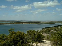 Yangie Bay
 -
 Almonta Beach


See also
- Protected areas of South Australia
- Avoid Bay Islands Conservation Park
- Kellidie Bay Conservation Park
- Mount Dutton Bay Conservation Park
- Whidbey Isles Conservation Park
References
- ^ a b "Terrestrial Protected Areas of South Australia (refer 'DETAIL' tab )". CAPAD 2016. Australian Government, Department of the Environment (DoE). 2016. Retrieved 21 February 2018.
- ^ Slater, John W. (2 December 1982). "NATIONAL PARKS AND WILDLIFE ACT, 1972-1981: SECTIONS 28 AND 43—CROWN LANDS CONSTITUTED AS NATIONAL PARK—COFFIN BAY NATIONAL PARK—DECLARATION AS TO MINING RIGHTS" (PDF). The South Australian Government Gazette. Government of South Australia. p. 1750. Retrieved 14 February 2019.
Section 665, Hundred of Lake Wangary, County of Flinders.
- ^ "Protected Areas Information System - reserve list (as of 25 November 2014)" (PDF). Department of Environment Water and Natural Resources. Archived (PDF) from the original on 2 July 2015. Retrieved 8 January 2015.
- ^ "Former Coffin Bay Whaling Site (designated place of archaeological significance) Coffin Bay National Park". South Australian Heritage Register. Department of Environment, Water and Natural Resources. Retrieved 12 February 2016.[permanent dead link]
- ^ "MARINE PARK 5 Thorny Passage" (PDF). Department of Environment, Water and Natural Resources. Archived (PDF) from the original on 25 August 2014. Retrieved 4 February 2015.
- ^ "Important Bird Areas factsheet: Coffin Bay". BirdLife International. 2014. Retrieved 29 October 2014.
External links
- Coffin Bay National Park official webpage
- Coffin Bay National Park webpage on protected planet
- v
- t
- e
- Adelaide International Bird Sanctuary–Winaityinaityi Pangkara
- Belair
- Canunda
- Cleland
- Coffin Bay
- Coorong
- Dhilba Guuranda-Innes
- Flinders Chase
- Deep Creek
- Glenthorne National Park–Ityamaiitpinna Yarta
- Gawler Ranges
- Great Australian Bight Marine
- Ikara-Flinders Ranges
- Kati Thanda-Lake Eyre
- Lake Frome
- Lake Gairdner
- Lake Torrens
- Lincoln
- Malkumba-Coongie
- Mount Remarkable
- Munga-Thirri–Simpson Desert
- Murray River
- Naracoorte Caves
- Nullarbor
- Nilpena Ediacara
- Onkaparinga River
- Vulkathunha-Gammon Ranges
- Wapma Thura–Southern Flinders Ranges
- Witjira
- Aberdour
- Acraman Creek
- Aldinga Scrub
- Althorpe Islands
- Angove
- Avoid Bay Islands
- Baird Bay Islands
- Bakara
- Bandon
- Bangham
- Barwell
- Bascombe Well
- Baudin
- Baudin Rocks
- Beachport
- Beatrice Islet
- Belt Hill
- Beyeria
- Big Heath
- Billiatt
- Bimbowrie
- Bird Islands
- Black Hill
- Black Rock
- Boondina
- Breakaways
- Brookfield
- Bullock Hill
- Busby Islet
- Butchers Gap
- Calectasia
- Calpatanna Waterhole
- Cap Island
- Cape Blanche
- Cape Gantheaume
- Cape Willoughby
- Caralue Bluff
- Carappee Hill
- Carcuma
- Caroona Creek
- Carpenter Rocks
- Carribie
- Chadinga
- Charleston
- Christmas Rocks
- Clements Gap
- Clinton
- Cocata
- Cooltong
- Corrobinnie Hill
- Cox Scrub
- Cromer
- Cudlee Creek
- Custon
- Cygnet Estuary
- Danggali
- Darke Range
- Desert Camp
- Dingley Dell
- Douglas Point
- Dudley
- Eba Island
- Elliot Price
- Eric Bonython
- Ettrick
- Ewens Ponds
- Fairview
- Ferguson
- Ferries-McDonald
- Finniss
- Fort Glanville
- Fowlers Bay
- Franklin Harbor
- Furner
- Gambier Islands
- Gawler Ranges
- Geegeela
- Giles
- Glen Roy
- Goose Island
- Gower
- Grass Tree
- Greenly Island
- Guichen Bay
- Gum Lagoon
- Gum Tree Gully
- Hacks Lagoon
- Hale
- Hallett Cove
- Hanson Scrub
- Heggaton
- Hesperilla
- Hincks
- Hogwash Bend
- Hopkins Creek
- Horsnell Gully
- Ironstone Hill
- Jip Jip
- Kaiserstuhl
- Kapunda Island
- Karte
- Kathai
- Kellidie Bay
- Kelly Hill
- Kelvin Powrie
- Kenneth Stirling
- Kinchina
- Kulliparu
- Kungari
- Kyeema
- Lake Frome
- Lake Gilles
- Lake Hawdon South
- Lake Newland
- Lake St Clair
- Lashmar
- Lathami
- Laura Bay
- Lawari
- Lesuer
- Leven Beach
- Lincoln
- Lipson Island
- Little Dip
- Lowan
- Lower Glenelg River
- Maize Island Lagoon
- Malgra
- Mamungari
- Mantung
- Marino
- Mark Oliphant
- Marne Valley
- Martin Washpool
- Martindale Hall
- Mary Seymour
- Media Island
- Messent
- Middlecamp Hills
- Mimbara
- Minlacowie
- Moana Sands
- Mokota
- Monarto
- Monarto Woodlands
- Montacute
- Moody Tank
- Morgan
- Morialta
- Mount Billy
- Mount Boothby
- Mount Brown
- Mount Dutton Bay
- Mount George
- Mount Magnificent
- Mount Monster
- Mount Scott
- Mount Taylor
- Mowantjie Willauwar
- Mullinger Swamp
- Munyaroo
- Murrunatta
- Mylor
- Myponga
- Nene Valley
- Nepean Bay
- Neptune Islands
- Newland Head
- Ngarkat
- Ngaut Ngaut
- Nicolas Baudin Island
- Nixon-Skinner
- Nuyts Archipelago
- Nuyts Reef
- Olive Island
- Padthaway
- Pandappa
- Para Wirra
- Paranki Lagoon
- Parndana
- Peachna
- Peebinga
- Pelican Lagoon
- Penambol
- Penguin Island
- Penola
- Piccaninnie Ponds
- Pigface Island
- Pike River
- Pine Hill Soak
- Pinkawillinie
- Point Bell
- Point Davenport
- Point Labatt
- Pooginook
- Poonthie Ruwe
- Porter Scrub
- Pualco Range
- Pullen Island
- Pureba
- Ramco Point
- Ramsay
- Red Banks
- Reedy Creek
- Ridley
- Rilli Island
- Rocky Island (North)
- Rocky Island (South)
- Roonka
- Rudall
- Salt Lagoon Islands
- Sandy Creek
- Sceale Bay
- Scott
- Scott Creek
- Seal Bay
- Searcy Bay
- Seddon
- Shannon
- Sheoak Hill
- Simpson
- Sinclair Island
- Sir Joseph Banks Group
- Sleaford Mere
- Spring Gully
- Spring Mount
- Stipiturus
- Swan Reach
- Talapar
- Talisker
- Tallaringa
- Tantanoola Caves
- Telford Scrub
- The Dutchmans Stern
- The Knoll
- The Pages
- The Plug Range
- Thidna
- Tilley Swamp
- Torrens Island
- Troubridge Island
- Tucknott Scrub
- Tumby Island
- Venus Bay
- Verran Tanks
- Vivigani Ardune
- Vivonne Bay
- Wabma Kadarbu Mound Springs
- Wahgunyah
- Waitpinga
- Waldegrave Islands
- Wanilla
- Wanilla Land Settlement
- Warren
- Warrenben
- West Island
- Wharminda
- Whidbey Isles
- White Dam
- Whyalla
- Wiljani
- Wills Creek
- Winninowie
- Wittelbee
- Woakwine
- Wolseley Common
- Yalpara
- Yeldulknie
- Yulte
- Yumbarra
- Marine protected areas of South Australia
- List of protected areas in Adelaide


